* Overton Park and Foster Park [OVERTON]
* Trinity Park (with notes on the FW
Botanic Garden) [TRINITY ]
* Forest Park (with notes on the FW Zoo
area) [FOREST]
* Tillery Park [TILLERY]
* Collett Park
[COLLETT]
* Lake Como
Park [COMO]
* Rockwood Park
[ROCKWOOD]
* Kelly Park
[KELLY]
Fort
Worth has wonderful city parks. Almost
all of the larger ones are along the Trinity River and its tributaries, where
neighborhoods and businesses didn’t develop because of periodic flooding. Control measures since the 1950’s have
mostly eliminated problems of flooding and made these areas more available for
use. Because it follows the major
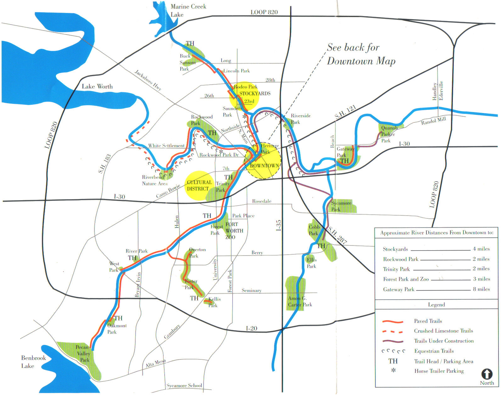
waterways, the park system is essentially “linear,” and a system of hike &
bike trails is developing to connect many of the parks (see maps –– FW parks and trails; Trinity
Trails; Trinity
Trails West; Trinity
Trails East). A list of all Fort Worth city parks, with
the address of each and a checklist of its facilities, is provided by the city
(allFWparks).
Most
of the Fort Worth parks have a mix of native trees, some growing there
naturally before the park was established, and others that have been planted
since, often not native to the area. In
some of the larger parks, small areas of natural woods or natural vegetation
have been left undeveloped –– most of these remaining because they are less
accessible to mowers or difficult to reach at all because of water. See examples (so far) of these kinds of tiny
‘preserves’ in Forest Park, Overton Park, and Trinity Park. Shrubs in the parks, especially along
boundary lines, woods edges, and fencerows, commonly are a mix of native and
naturalized species.
I
hope these brief descriptions, with photos and maps, will add a bit to the
enjoyment of Fort Worth parks, whether in just walking among the trees or in
learning to identify some of the species.
And in the next decades, especially if the native species are gradually
replaced by others, it will be interesting to know what the parks once were
like.
Park pages in progress, to be added
Spring 2010:
* updates on Kelly, Lake
Como, and Rockwood parks
* Riverbend Natural Area
* Saunders Park
* Trees and
shrubs of Fort Worth parks -- photos and
notes on the species that occur in the parks, for help in identifying the
plants.
Two natural areas have been
formally designated along the Trinity River within the city of Fort Worth –– the Riverbend
Nature Area and the Fort Worth Nature Center and Refuge –– as well
as scattered, smaller areas of natural vegetation along the Trinity River
greenbelt.
The
Fort Worth Nature Center and Refuge (FWNC&R) includes 3624 acres on the
northwest side of the city, along Lake Worth just inside the city limits –– an
area of “forests, prairies, and wetlands reminiscent of how much of the Fort
Worth/Dallas metroplex once looked.”
There one can get an ecological perspective of the mostly ‘floodplain’
and ‘river terrace’ woods of the larger parks within the city. Like the more urban parks, administration of
the Nature Center is through the Fort Worth Parks and Community Services
Department.
Eagle Mountain
Park (EMP) is outside of the city –– on the
east shore of Eagle Mountain Lake in northwest Tarrant County –– but it’s a
wonderful, close-by asset for the city folks.
Most of the park’s 400 acres are natural, maintaining its environmental
integrity and watershed value and giving the public an opportunity to enjoy the
native plants and wildlife in a scenic setting. There are hiking trails (trail map), a
handicap-accessible overlook, and two large pavilions with informational signs
outlining the park’s history, trail system, plants and trees, animals, and
landscape. The park is administered
through the Tarrant Regional Water District and was made possible by “generous
donations from TRWD, Tarrant County, TXU, AT&T Foundation, City of Fort
Worth, Bass Foundation, Amon Carter Foundation, Chesapeake Energy, the general
public, and anonymous donors.”
TRINITY RIVER VISION and TRINITY
TRAILS SYSTEM
Through
their connection with the river system, Fort Worth parks are closely associated
with the Trinity River Vision Master Plan, which encompasses 88 miles of the
Trinity River and its greenbelts and tributaries throughout the Fort Worth
area. The vision is to keep the river
“beautiful, accessible, enjoyable, and productive and to make sure it remains a
valuable asset for the entire community.”
The Plan addresses issues of the environment, ecosystems, flood
protection, recreational opportunities, access to the waterfront, preserving
green space, and urban revitalization based around the river. The conservation portion of the Master Plan
is here (TRV
Conservation Plan).
The
Trinity Trails System (TTS) is a planned (and developing) continuous
public-access recreation corridor with a multi-use trail (hike, bike,
equestrian, and/or nature trails) along the Trinity River Corridor/Greenway in
north-central Texas and northward to the Red River. From
the ‘spine’ near downtown Dallas, the completed corridor will run
* west 75
miles to Fort Worth as far as Benbrook and Eagle Mountain Lakes
* southeast 50 miles to the
Dallas/Ellis Co. line
* north 125
miles along the Elm Fork to Lewisville Lake and Ray Roberts Lake, then along
major highway and rail corridors to Lake Texoma at the Oklahoma border.
A newly completed section of the Trinity
Trail System runs along Farmers Branch Creek, from the Trinity River to
Pumphrey Drive, just northeast of Westworth Village. [trail
map] The
new trail is about 0.8 mile long and runs beside the creek, which has a
limestone bottom and a natural waterfall, crossing it at one point by a
picturesque bridge. “The trail, built
by the Tarrant Regional Water District at a cost of $260,000, has been open
about a month, and many already believe that it is one of the most scenic
stretches of the 40-plus miles that make up the Trinity Trail system. …
Unlike most of the Trinity Trails, the Farmers Branch Creek trail is not
part of a federally protected flood-control zone, meaning trees can hug the
creek bank, and hikers can easily amble down to the water’s edge. …
For now, seeing the waterfall still requires some effort. It’s about a 3-mile one-way bike ride, walk,
or run from the trailhead along White Settlement Road in west Fort Worth. A parking lot is scheduled to be completed
at the Pumphrey Drive trailhead, near the Naval Air Station’s main entrance, by
the end of summer.” From
an article by Bill Hanna in the Star-Telegram, 21 Dec 2009: “A Trinity River
gem becomes more accessible.”
---------------------------------------------
Last update: 21 December 2009
Guy Nesom